Search This Blog

Thursday, November 21, 2013

Facts for Pie

Geography Week Facts 
(given to us by members of our community in exchange for apple pie):


-Washington State has more glaciers than the other 47 contiguous states combined. (Linda)
-Equatorial Guinea is the only country in Africa to have Spanish as its official language (Hunter)
-The Mariana Trench is the deepest spot in the ocean, 35,760 feet below sea level (Nate)
-“Home on Range” is the official state song of Kansas (Eva)
- Azkaban (the prison in Harry Potter) is named for a small lake in Russia (Abbey)
-Crater Lake is the deepest lake in the United State.  At one point it was a 14,000+ foot mountain, which imploded into itself (Lisa)
-The reason they know that the earth’s magnetic poles flip is that they’re able to look at minerals within an ocean trench to see evidence of the change (Andrew L)
-In the 1800s the New Madrid fault line caused an earthquake in the Midwest that was felt in New York (Andrew L)
-The Red River in Minnesota flows North.  You can travel from Minnesota to Hudson Bay on it. (Andrew K)
-Northeast Iowa is called the “driftless” region because the glaciers scraped the rest of Iowa flat but missed the driftless region leaving it forested and rolling (Peter)
-Harney Peak in South Dakota is 7,244 feet—it is the highest peak in the U.S east of the Rockies (Dale)
-There’s a town in Quebec, Canada called La Tuque named after a hill that looks like a Tuque (James)
-The first place you can see the sunrise in the United States is on the top of Cadillac Mountain on Mount Desert Island in Arcadia National Park (Andy)
-In Northern Minnesota there’s a lake called Cass Lake—it has an island called Star island—it’s the only freshwater lake with an island with a freshwater lake inside of it (Claire)
-Vatican City is the smallest country (Sharon)
-48 of Montana’s 52 counties are considered frontier counties, which means that there are less than 6 people per square mile (Tressa)
-In 1888 Helena, Montana had more millionaires per capita than anywhere else in the U.S. (Tressa)
-The lowest point on land you can stand on is the beach of the Dead Sea—it’s about 1,500 feet below sea level (David)
-A device for remembering coastal countries in Africa from Egypt, around the west coast of the country, ending with Equatorial Guinea: Every Lotto Ticket a moron wins my sister guzzles great glasses of slurpy leaving ice globs tightly bonded near the crystal’s edge. (Rosa)
-If you drained Lake Chelan it would cover Washington at a depth of 4 inches (Chris)
-In North Central Mauritania, there’s something called a Richat structure that’s 31 miles in diameter—it’s a symmetrical uplift made by erosion that you can see from space (Lisa)
-In Papua New Guinea there are over 800 languages and dialects (Janine)
-The Northernmost point of the continental United States is in Minnesota.  However you can’t get there by car—you either have to boat or by way of Canada (Ellen)
-The two cities I lived in before coming here were on the Mississippi River (Ellen)
-The hottest temp ever to be recorded in the world is believed to be 134 degrees F in Furnace Creek Ranch, CA recorded on 10/7/1913 (Bonnie)
-The shortest river in North America is the Chelan River (Rosa)
-It’s 550 miles to hike from Oregon to Canada on the PCT (Natalie)
-If you drilled a hole through the middle of the world straight through (from where we are now) you would end up in the Indian Ocean, right off the coast of Madagascar (Cindy)

Wednesday, November 20, 2013

The average American's food travels 1,500-2,500 miles before reaching his/her table

Learning where our food comes from:

Places we import (some of) our food from:
Chelan, WA-0 miles (apples, lettuce)
Stehekin, WA-0 miles (by car) (kale)
Tonasket, WA-80 miles (beef)
Eugene, OR-174 miles (coffee)
Roy, WA-213 miles (eggs)
Palouse, WA-213 miles (flour, lentils, garbanzo beans)
Euphrata, WA-61.2 miles (cod, salmon)
Brewster, WA-27.2 miles (potatoes)
Seattle, WA-180 miles (cream, milk, cheese)
Twisp, WA-52.3 miles (whole wheat flour)
Pendleton, OR-238 miles (pork)
California (Sysco Central)-aprox. 872 miles (lettuce, oranges, cream of wheat, kale)
Guatemala-aprox. 3,551 miles (coffee)
Alaska-aprox. 2,281 miles (cod, salmon)

What ratio of the food we researched comes from Washington?
9:14 or 9 of 14 or 9/14 

What percentage is that?
64%

What ratio of the food we researched comes from California?
4:14 or 4 of 14 or 4/14

What percentage is that?
28%

What is the mean (average) distance our food travels?
547.48 miles

Eating Geography

Trading pie for geography facts in the dining hall---


Mapping Apple Pie

Objective: To connect to geography, ecology, and economics using food.
Check out our: Apple Pie Map

Making pie from Washington ingredients
Ingredients:
(For the ingredients we where we didn’t know the exact location they were grown/produced, we searched online to find out where they usually come from)

 Apple Crumble:
-Flour (Palouse, WA) 120 grams
-Oats (123 grams
-Sugar (Brazil) 63 grams
-Cinnamon (Sri Lanka) 2 grams
-Butter (Seattle, WA) 113 grams
-Apples (Wenatchee, WA/Tonasket,WA) 547 grams

Grams grown/produced in Washington=780 grams
Percent of total crumble grown/produced in Washington=81%

Pie:
-Flour (Palouse, WA) 302 grams
-Salt (California) 7 grams
-Butter (Seattle, WA) 215 grams
-Water (Holden Village, WA) 111 grams
-Apples (Wenatchee, WA/Tonasket,WA) 968 grams
-Sugar (Brazil) 32 grams
-Cinnamon (Sri Lanka) 2 grams

Grams grown/produced in Washington= 1,596 grams
Percent of total pie grown/produced in Washington= 91%

Tuesday, November 19, 2013

National Geography Week preparations

Grade Level: 6

Objective: To celebrate geography through creating a community event and to learn about ecology and economics through engaging with the question of where our food comes from.

GeoWeek is November 17-23rd.  K and I have decided to highlight GeoWeek in our community through an event we're organizing tomorrow at lunch.

Our celebration has three components:
1-Make and share a map of food sources for our community
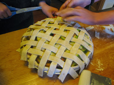
2-Make an apple pie, calculating what percentage of that pie is made from ingredients produced or grown in the state of Washington
3-Trade pieces of pie for geography facts during a community-wide geography celebration tomorrow at lunch


Mapping where our foods are grown and manufactured: regionally, nationally, and internationally 
Places we import (some of) our food from:
Chelan, WA-0 miles (apples, lettuce)
Stehekin, WA-0 miles (by car) (kale)
Tonasket, WA-80 miles (beef)
Eugene, OR-174 miles (coffee)
Roy, WA-213 miles (eggs)
Palouse, WA-213 miles (flour, lentils, garbanzo beans)
Euphrata, WA-61.2 miles (cod, salmon)
Brewster, WA-27.2 miles (potatoes)
Seattle, WA-180 miles (cream, milk, cheese)
Twisp, WA-52.3 miles (whole wheat flour)
Pendleton, OR-238 miles (pork)
California (Sysco Central)-aprox. 872 miles (lettuce, oranges, cream of wheat)
Guatemala-aprox. 3,551 miles (coffee)
Alaska-aprox. 2,281 miles (cod, salmon)

Andy Goldsworthy for kids: making environmental art about the changing seasons

Grade Level: Elementary

Objective: To engage with science and nature through art-making in an exercise inspired by environmental artist Andy Goldsworthy.


Monday, November 18, 2013

Three Fossil Activities

Grade Level: Elementary

Step C, Cast and Mold
1. Fossilized Sugar Cubes:
Objective: To show how way different materials decay at different rates
A: Hot glue four sugar cubes together
B: Let dry over night
C: Place sugar cube structure in a strainer, run warm water over it
D: What happens to the sugar?  What happens to the glue?  What can we learn about the way bodies of living things decay from this experiment?

2. Cast and Mold:
Objective: To learn the difference between the cast and the mold of a fossil
A: Coat the ridges of a rock, stick, or shell with Vaseline
 B: Press the rock, stick, or shell into a clump of clay.
C: Remove carefully.
D: Drizzle white glue in the imprint.
 E: Let glue harden--then remove.
F: Which part is the cast?  The mold?

3. Imprints:                                
Objective: To explore other ways fossils are formed 
A: Dip a rock, stick, leaf, or branch in paint
 B: Press the object on a sheet of paper
C: Remove carefully.  
D: Look at the resulting shape?  What can you observe from the imprint left by the shape of the object you pressed.